Self Guided
Trailhead: Fanore Beach Car Park, Fanore, Co. Clare
Services: Fanore (1km) and Ballyvaughan (14km)
Dist/Time: 26km / 5hr-6hrs
Difficulty: Hard
Terrain: Green roads, tracks and mountain paths
To Suit: Higher than average level of fitness
Min. Gear: Sturdy walking boots, waterproofs, rucksack, fluid, snacks, mobile phone
Download map: Black Head Loop Walk
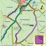
Trailhead: Ballyvaughan, Co. Clare
Services: Ballyvaughan village
Dist/Time: 8kn / 2hrs-2hrs 30 mins
Difficulty: Easy
Terrain: Surfaced roadway, green roads, tracks, cross country
To suit: Medium level of fitness
Min Gear: Trekking Shoes, waterproofs, fluid, snacks, mobile phone
Download map Ballyvaughan Wood Loop
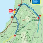
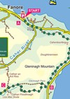
Trailhead: Fanore Beach Carpark, Co. Clare
Services: Fanore, Co. Clare
Dist/Time: 14.5km/3-4hrs
Difficulty: Moderate
Terrain: Mix of minor roadways and green roads
To Suit: Medium level of fitness
Min. Gear: Sturdy walking boots, waterproofs, rucksack, fluid, snacks, mobile phone
Download map Caher Valley Loop Walk
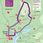
Trailhead: Cassidy’s Pub, Carron Village, Co. Clare
Services: Carron, Corofin (12km), Ballyvaughan (15km), Co. Clare
Dist/Time: 9km/3-4hrs
Difficulty: Difficult
Terrain: Mix of minor roads, animal tracks and green lanes
To Suit: Higher than average levels of fitness
Min. Gear: Sturdy walking boots, waterproofs, rucksack, fluid, snacks, mobile phone
Download map Carron Loop Walk
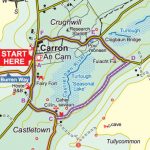
Trailhead: Opposite Cassidys Pub, Carran
Services: Services available seasonally at Carran, year round at Corrofin
Distance: 5Km
Time: 1-1.5hrs
Difficulty: Easy
Terrain: Short section of regional road, mostly minor country roads
To Suit: Medium levels of fitness, buggy friendly
Download map Carron Turlough Loop Walk
Time: From 30mins to 3 hrs.
Terrain: Can be uneven and quite steep in places.
These trails are not wheelchair accessible.
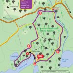
Green Arrow Route (Nature Trail)
Grade: Moderate
Distance: 2km
Time: 40 mins
Climb: 20m
Orange Route (Knockaunroe Turlough)
Grade: Moderate
Distance: 1.3km
Time: 30 mins
Climb: 20m
Green Route (Mullaghmor Return)
Grade: Very Difficult Remote/Upland
Distance: 4.3km
Time: 2hrs 20mins
Climb: 140m
Blue Route (Mullaghmor Loop)
Grade: Very Difficult Remote/Upland
Distance: 5.5km
Time: 2hrs 30mins
Climb: 140m
Red Route (Mullaghmor Traverse)
Grade: Very Difficult Remote/Upland
Distance: 5km
Time: 2hrs 40mins
Climb: 140m
Brown Route (Slieve Carran)
Grade: Moderate
Distance: 2.5km
Time: 1hr 30mins
Climb: 30m
Yellow Route (Slieve Carran)
Grade: Moderate
Distance: 2km
Time: 1hr
Climb: 20m
Download map Burren National Park Walks
For further information please visit Burren National Park website
Distance: 123km
Estimated Time: 5 days. Each section represents approximately a full days walking (Lehinch-Doolin/ Doolin Ballyvaugan/ Ballyvaughan Carran/ Carran-Corrofin/ Carran Tubber).
Grade: Moderate to difficult
To Suit: Average fitness, casual walkers
Minimum Gear: Sturdy walking boots, waterproofs. Rucksack, fluid, snacks, mobile phone.
Terrain: The Way follows a mix of green road, pathway, minor roadway, and grassy/rocky track, with an initial steep climb out of the Caher Valley and steep descent to Feenagh Valley.
Trailheads: Lahinch, Doolin, Lisdoonvarna, Ballyvaghan, Carran, Corrofin and Tubber.
Trailhead 1 – Lahinch. Located on the coast, Lahinch is 3km west of Ennistymon on the N67.
Trailhead 2 – Doolin. Doolin village is located on the R479, off the N67, and 8km from the Cliffs of Moher.
Trailhead 3 – Lisdoonvarna. The town of Lisdoonvarna is located approximately 34km north of Ennis on the N67.
Trailhead 4 – Ballyvaughan. The village of Ballyvaughan is located on the N67 and is 39km from Ennis.
Trailhead 5 – Carran. The village of Carran is located between Ballyvaughan and Corrofin approximately 3km to the East of the R480.
Trailhead 6 – Corrofin. The village of Corrofin is located on the R476 between Ennis and Lisdoonvarna and is approximately 13km from Ennis.
Download map Burren Way
A walk that’s mostly off road between Fanore and Ballyvaughan taking you on the old famine road around Blackhead.
Duration: 5-6 hrs
Suitable for: High levels of fitness
Access: Green roads, minor roadways, woodland tracks
Download map Fanore to Ballyvaughan Trek
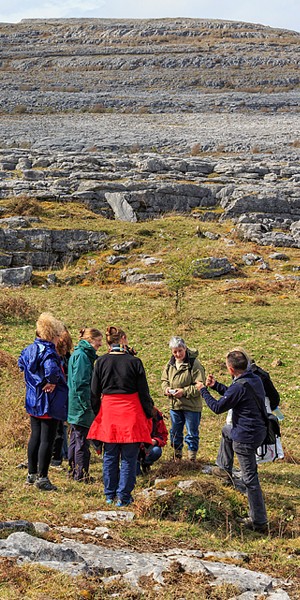
Guided Walks